A joint research team from the National Time Service Center(NTSC) of the Chinese Academy of Sciences(CAS), Xinjiang Institute of Ecology and Geography CAS, Shandong University of Science and Technology, and Hohai University successfully achieved centimeter-level water level monitoring of the Kalabuli Reservoir in Xinjiang using Global Navigation Satellite System Interferometric Reflectometry (GNSS-IR) technology.
The related results were published in the journal Advances in Space Research under the title "GNSS-IR Water Level Monitoring for Complex Environments: Application to Kalabeily Reservoir in Xinjiang, China."
GNSS-IR is a technique that extracts characteristics of reflecting surfaces by analyzing the interference phenomenon generated when direct and reflected satellite signals superimpose at the antenna. It offers the advantages of low cost and high precision. Currently, this technology has been widely applied in water level monitoring for various types of water bodies such as oceans, reservoirs, rivers, and lakes. It is also utilized in the retrieval of environmental parameters including soil moisture, snow depth, and sea wind, and has become a key technological field actively promoted at the national level.
The Kalabelly Reservoir is located in the Kezi River Basin of the Xinjiang Uygur Autonomous Region. Influenced by the operational mode of "sediment discharge during flood seasons and water storage during dry seasons" the annual water level of the reservoir fluctuates significantly. f As a result, the effective reflection zone of GNSS signals varies notably with the rise and fall of the water level. In such complex environments, the traditional uniformly selected elevation angle range (USEAR) method cannot adequately adapt to the dynamically changing reflection zone. This often leads to situations where the reflection points deviate from the water surface, which leads to abnormal inversion outcomes and maks it difficult to achieve long-term, continuous, high-precision monitoring.
To address this challenge, researchers proposed a method for dynamically selecting the elevation angle range (DSEAR). This method is grounded in the geometric properties of the Fresnel zone. It dynamically determines the suitable elevation angle range for each day by integrating the median reflector height (RH) retrieved from the previous day's data with pre-defined boundaries of the effective water surface reflection area. Compared to conventional methods, the DSEAR approach effectively excludes non-aqueous reflected signals, broadens the usable elevation angle range, and increases the effective reflection area. Consequently, it significantly enhances both the success rate and the reliability of water level retrieval, laying a solid foundation for real-time reservoir water level monitoring.
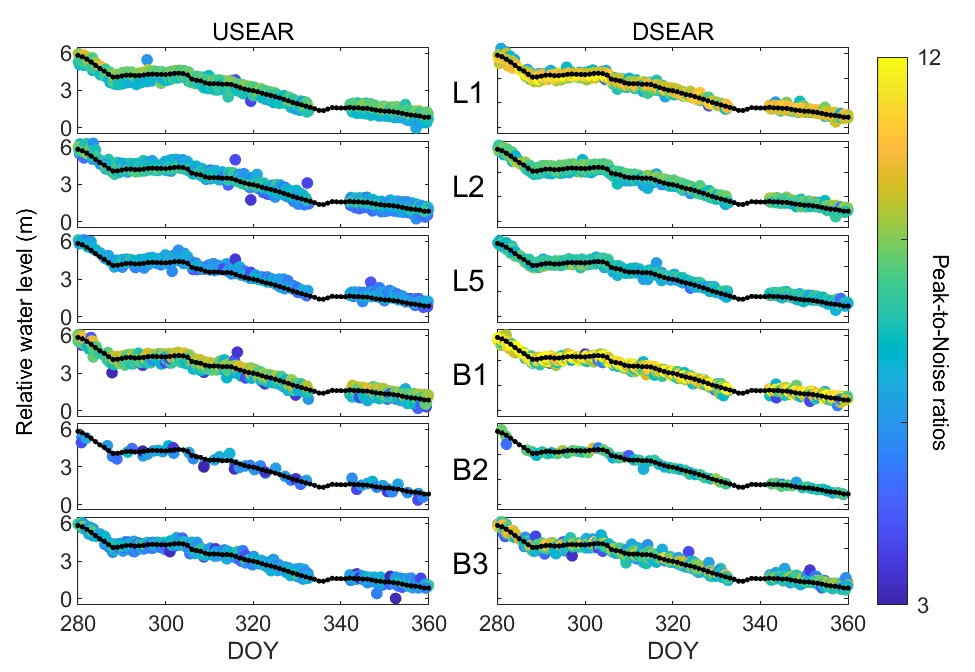
Figure 1 Comparison of static water level retrieval sequences using two different elevation angle selection methods (Imaged by NTSC)
To further enhance retrieval accuracy, the researchers also introduced a multi-station multi-signal water level retrieval algorithm based on a robust estimation strategy. The final water level retrieval achieved an accuracy of 4.07 cm. Compared to the single-station multi-signal retrieval method, the accuracy was improved by up to 44.70%. These results confirm the significant potential of GNSS-IR technology in complex environments.
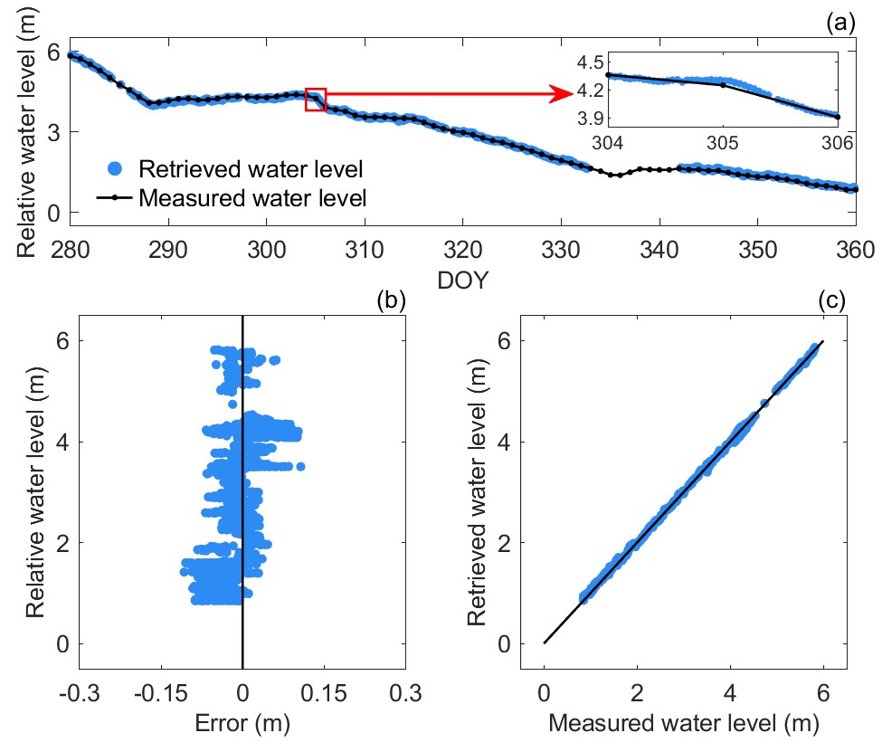
Figure 2 Water level retrieval sequence and error analysis from the multi-station multi-signal combination at Kalabeily Reservoir. (Imaged by NTSC)