
Recently, the Aerospace Information Research Institute (AIR) of the Chinese Academy of Sciences, in collaboration with the National Space Science Center (NSSC) of the Chinese Academy of Sciences and the Academy of Forestry and Grassland Inventory and Planning, National Forestry and Grassland Administration, organized and implemented the "Vegetation and Soil Water Content Remote Sensing Experiment" in the Saihanba Mechanized Tree Farm and Yudaokou Pasture in Hebei Province. This experiment marks the first international attempt to conduct perspective remote sensing of water content in the soil-vegetation-atmosphere continuum using an aerial platform. It is a crucial component of the "Luanhe River Basin Multi-scale Remote Sensing Joint Experiment from Space, Air, and Ground," which is led by the NSSC.
The Luanhe River, an important river in the Haihe River Basin, serves as the "water tap" for the Beijing-Tianjin-Hebei region, playing a crucial role in ecological support and water conservation for the area. Comprising a complex ecosystem of mountains, rivers, forests, farmlands, lakes, grasslands, and sandy areas, the Luanhe River Basin is an ideal location for exploring multi-element remote sensing mechanisms, innovating multi-source remote sensing methods, and validating advanced remote sensing technologies.
Husiletu, Director and Researcher at the Key Laboratory of Remote Sensing and Digital Earth, Aerospace Information Research Institute (AIR), pointed out, "Vegetation plays a pivotal role in water transport between the land and atmosphere. It acts as both a reservoir for terrestrial water resources and a natural water pump. Traditionally, research on water transport in the soil-vegetation-atmosphere continuum has been confined to microscopic point scales, limiting our understanding of the water balance in entire ecosystems. There is an urgent need to develop modern technological means capable of conducting observations on larger spatial scales."
This perspective remote sensing experiment primarily utilizes microwave technology. Microwaves,with longer wavelengths than visible light and thermal infrared,possess strong penetrating capabilities,enabling them to penetrate clouds and vegetation,and function normally even at night and during rainy or cloudy days. Additionally,different microwave bands interact differently with various parts of vegetation. For instance,longer wavelength bands are more suitable for observing the stem portions of vegetation,while shorter wavelength bands are better suited for observing the canopy and leaves.
Zhao Tianjie,a researcher at the Key Laboratory of Remote Sensing and Digital Earth, AIR, explained, "This remote sensing experiment employs multi-channel microwave coordinated observations from the L-band to the Ka-band, a perspective observation technique akin to a doctor using a CT scan to diagnose internal conditions of the human body. Researchers can delve into observing the internal water status and distribution within plants, and analyze in detail the entire water transport process from the soil, through the plant stem, to the canopy, and into the atmosphere. This not only aids in our in-depth understanding of plant growth and mortality mechanisms from a physiological perspective but also reveals how ecosystems respond to changes in water stress."
The research team utilized the national major science and technology infrastructure—the Chinese Aeronautic Remote Sensing System,which was constructed and operated by the Aerial Remote Sensing Center of the Chinese Academy of Sciences. This system,mounted on a medium-sized domestic flight platform—the MA60 aircraft—integrates six types of Earth observation windows,making it the most comprehensive aerial remote sensing platform in China currently.
Pan Jie, Director and Researcher at the Aerial Remote Sensing Center of the Chinese Academy of Sciences, introduced that the airborne three-band (L/S/C) multi-angle imaging microwave radiometer carried in this experiment is a newly developed one-dimensional synthetic aperture microwave radiometer jointly developed by AIR and NSSC. This new-type microwave radiometerabandons the mechanical scanning imaging method of traditional real-aperture microwave radiometers and, compared with traditional ones, boasts higher spatial resolution, enabling it to accurately capture the water content within vegetation and soil. This also marks that Chinese Aeronautic Remote Sensing System now possesses multi-band, full-polarization passive microwave observation capabilities with different imaging systems.
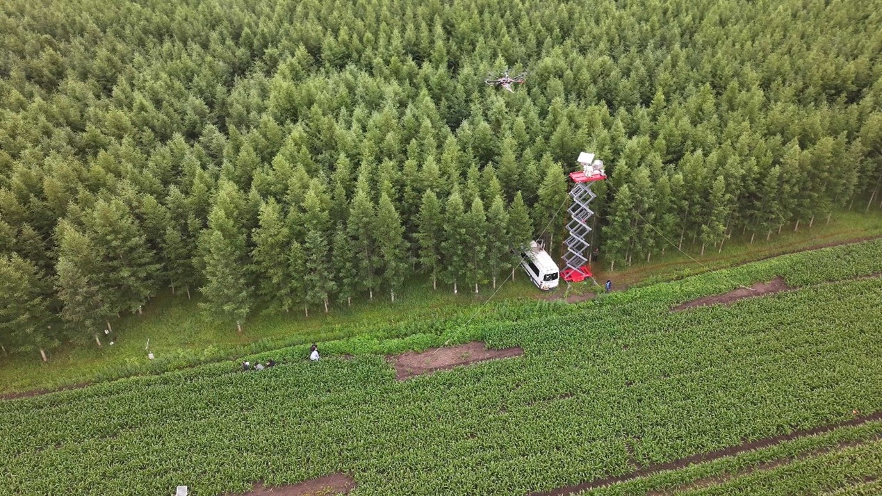
In synchronization with manned aerial remote sensing,researchers also employed drones equipped with microwave radiometers,thermal infrared imagers,multispectral cameras,and other devices to conduct more refined-scale collaborative observations. Meanwhile,long-term ground-based microwave radiation observation experiments,intensive soil temperature and humidity observation experiments,synchronous measurements of leaf equivalent water thickness,and determinations of plant stem and leaf water potential were carried out in key ground sample areas. Through these multi-level observation methods,a multi-scale observation system integrating satellite remote sensing,manned aerial remote sensing,drone remote sensing,and ground remote sensing has been formed.
This comprehensive approach not only enhances our understanding of the water transport processes within ecosystems but also provides valuable data and insights for ecological conservation,water resource management,and disaster prevention and mitigation in the Beijing-Tianjin-Hebei region and beyond.
The integrated space-air-ground data acquired from this experiment will be utilized to develop and validate intelligent remote sensing methods for key parameters of the terrestrial watercycle, such as soil moisture, vegetation moisture, vegetation water potential, atmospheric water vapor, and evapotranspiration, across multiple spatial and temporal scales. These methods will leverage aerospace technology to capture changes in the internal water status of plants and understand the complex interactions between soil moisture supply and atmospheric water demand. This work will provide technical support for the processing and innovative application of observations from new payloads on domestic satellites, including those for terrestrial water resources and ocean salinity detection. It will also offer scientific evidence for evaluating the ecological service function of "forests as water reservoirs," further enhancing forest soil water storage capacity and water productivity, and increasing water conservation and regulation abilities.
This experiment was jointly funded by the major project "Intelligent Remote Sensing of Key Parameters in the Terrestrial Water Cycle across Multiple Spatial and Temporal Scales" under theNational Natural Science Foundation of China and the project "Three-Dimensional Remote Sensing Mechanism Modeling and Quantitative Inversion Technology for Soil-Vegetation-Snow/Ice Systems Oriented towards Domestic Satellites" under the National Key Research and Development Program. Participating units in the experiment include universities, research institutes, and enterprises such as Wuhan University, Beijing Normal University, China University of Mining and Technology (Beijing), Northwest A&F University, Tsinghua University, Shandong Agricultural University, Jianghan University, Xi'an Jiaotong University, the Institute of Mountain Hazards and Environment, Chinese Academy of Sciences and Ministry of Water Resources, the Northeast Institute of Geography and Agroecology, Chinese Academy of Sciences, the Institute of Soil Science, Chinese Academy of Sciences, Zhejiang University, Central South University, Sun Yat-sen University, the Rural Industry Development Service Center of Henan Province, Beijing GreenValley International Co., Ltd., and Beijing Jiexiang Tiandi Information Technology Co., Ltd.
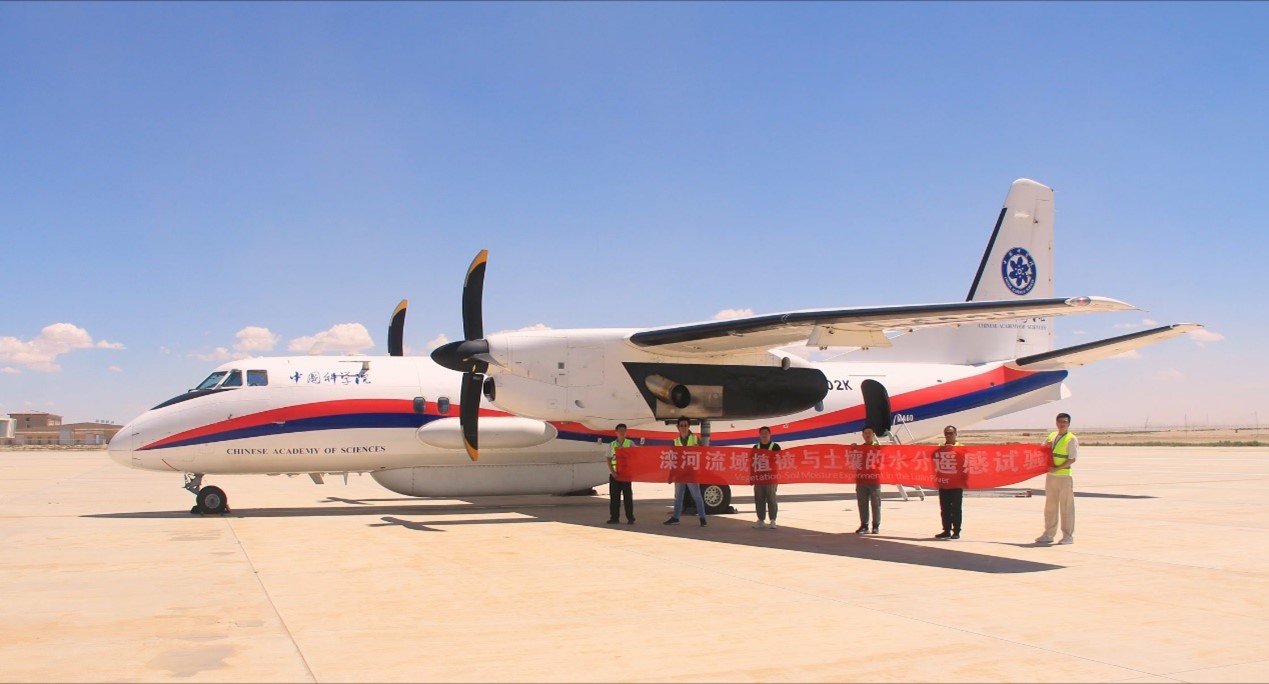
National Major Scientific and Technological Infrastructure for Chinese Aeronautic Remote Sensing System and its test personnel
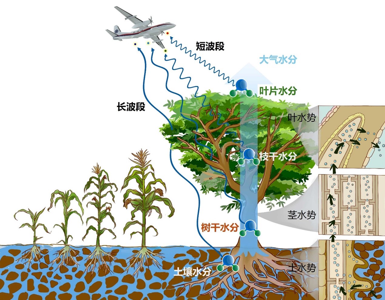
Principle of remote sensing of moisture perspective on the soil-vegetation-atmosphere continuum
Collaborative observation using unmanned aerial vehicles (UAVs) and ground-based microwave radiometers

