- Facilities at a Glance
- All Facilities
- Material
- Earth System and Environment
- Engineering Technology
- Space and Astronomy
- Particle and Nuclear Physics
- Energy
- Biology


- 1
- 2
- 3
Institute of Remote Sensing and Digital Earth,CAS
Contact: Li Wei
Phone: +86 10-82178919
Email: wli@ceode.ac.cn
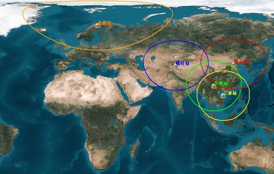
China Remote Sensing Satellite Ground Station (RSGS)
China Remote Sensing Satellite Ground Station (RSGS) was established and put into operation in 1986, with its Chinese name inscribed by Mr. Deng Xiaoping.
RSGS is not only a major national science and technology infrastructure but also a member of international ground stations group on Earth Observation. As one of the world’s busiest ground stations, RSGS has received, processed and archived more than 40 satellites,3.6million scenes of satellite imagery since 1986.
With fiveground stations built in Miyun, Kashi, Sanya, Kunming and North Pole(Kiruna, Sweden), the visible range of RSGS covers the entire Chinese territory and 70% of the land area of Asia, and global satellite remote sensing data can be accessedefficiently.
Starting operation in 1986 and equipped with 8 sets of antenna system as well as the corresponding data receiving, recording and transmitting facilities, the reception mask of Miyun Ground Station covers central China, northeast China and the neighbouring countries.
The Kashi Ground Station came into operation in 2008. Now it has five sets of 12-meter antenna systems and one set of 7.3-meter antenna system. Itsreception maskcovers western China and central Asian countries.
The Sanya Ground Station was put into use in 2010. It is equipped with five sets of 12-meter antenna systems.Its reception mask covers the South China Sea and neighbouring countries in southeast Asia.
The Kunming Ground Station was put into operation in 2015. It has one set of 7.3-meter antenna system. Its range coverssouthwest China and the neighbor regions.
The North PolarGround Stationis located in Kiruna, Sweden.It was put into operation in 2016. Now it has one set of 12-meter S/X/Ka-band antenna system, which realizes remote control and automation operation. The North Polar Ground Station can improve China's capability of acquiring global remote sensing data efficiently.
Based on 30 years’ development, RSGS has formed anintegrated satellite data receiving, transmitting, archiving, processing and distributing system with Beijing Headquarters as the operation management and data processing centre, and the Miyun, Kashi, Sanya, Kunming and North Polarground stations as the data receiving network. RSGShas become one of China’s core infrastructure facilities in the field of earth observation.
In 1986, RSGS began to receive and process data from LANDSAT-5. In 1993, it started to receive and process SAR (synthetic aperture radar) data from the ERS-1 satellite of ESA and the JERS-1 satellite of Japan, realizing all-weather earth observation. In 1997 and 2008 respectively, RSGS succeeded in receiving and processing data from the RADARSAT-1 and RADARSAT-2 satellites of Canada, with multimode and full polarization SAR capacity. From 1998, RSGS began to receive and process data from the French SPOT series satellites (including SPOT-1、SPOT-2、SPOT-4、SPOT-5、SPOT-6 and SPOT-7), providing high spatial resolution data to Chinese users. In 2015 RSGS started to receive and process French PLEIADES-1A and PLEIADES-1B satellites data, whose spatial resolution is up to 0.5 meter.
Since 1999 RSGS has been responsible for receiving data from all China’s earth observation satellites such as CBERS-01, CBERS-02, CBERS-02B, CBERS-04, HJ-1A, HJ-1B, HJ-1C, ZY-02C, ZY-03, ZY3-02, SJ-9A, SJ-9B, GF-1, GF-1B/1C/1D, GF-2, GF-3, GF-4, GF-5, GF-6 and CSES.
After the “CAS Strategic Priority Program on Space Science” was initiated in 2011, RSGS takes the responsible of tracking the near-earth satellites as well as receiving, recording and transmitting their data. The data service of RSGS was hence extended from the earth observation to the space science. From 2015, RSGS has succeeded in receiving data from China’s Dark Matter Particle Detection satellite (DAMPE, “WuKong”), SJ-10 satellite, Quantum Science Experimental satellite (QUESS, “MoZi”), and Hard X-ray Modulation Telescope satellite (HXMT, “HuiYan”).
The main technical capabilities of RSGS are as follows:
1) The data receiving system is capable of receiving satellite downlink data of the S, X and Ka band. As its core technical index, the data reception rate is up to 2*600Mbps(X band) and 4*1.5Gbps(Ka band), which is advanced in the world. The system is also able to track and rapidly capture highly dynamic and low-SNR satellite signals.
2) The data recording system is capable of data recording, transmitting and quick displaying in real-time, with a data recording capacity of up to 6000Mbps.
3) The data transmission system consists of five high-speed data transmission links between the Miyun, Kashi, Sanya, Kunming, North Pole Ground Stations and the Beijing Headquarters, with a bandwidth of 10000Mbps, 622Mbps, 622Mbps, 200Mbps and 450Mbpsrespectively to ensure the speed of data transmission.
4) RSGS owns several sets of foreign satellite data processing systems with data products being consistent with international standards of quality and specifications.
5) RSGS also provides severalkinds of satellite data service such as on-line query of archived data, handling of product orders, download and delivery of data products, etc. It manages more than 3.6 million scenes of historical archived catalogue data, and online archived standard productdata with a data size in excess of 230TB.
6) RSGS may set up a Virtual Ground Station (SatSee system) for users, especially for the neighbouring countries. The VGS is able to provide users with near real-time, full resolution quicklook images of remote sensing satellite data received by RSGS.
7) The operation management system manages more than 30 Chinese and foreign polar-orbiting earth observation satellites, geostationary earth observation satellites, and space science satellites by monitoring, scheduling and controlling their data receiving, recording and transmission systems, as well as the mission status and work performance.
Data Resource
-

The Earth Observation Data Sharing Program
The Earth Observation Data Sharing Program allows users to share mid-resolution satellite remote sensing datareceived by RSGS in downloading data from the Internet.
-
China GEOSS-DSNet
China GEOSS-DSNet,as a key infrastructure in ChinaGEOSS,has provided more than 29 million satellite archived metadata and 290 TB sample datasets in the fields of meteorology, ocean, land resource, and scientific research to global users.
NOTICE
-
Call for Proposals for HEPS Phase II Beamlines May 23,2022